Climate Change: At what Rate is Greenland’s Ice Sheet Melting?
What is Climate Change? What are the causes of Climate Change? What are the effects of Climate Change? We know many questions will pop up in your mind as soon as you will hear Climate Change. The facts is that Climate Change is real and most dangerous phenomena happening on Earth. Read more on erizon.com.au. The primary reason is the use of fossil fuels by humans, which releases many greenhouse gases into the atmosphere and it is getting trapped in the atmosphere thus increasing the average temperature of Earth. There are many stories we have covered that can be seen due to climate change whether its endangered North American bird species or its melting of ice in Antarctica which is forcing polar bears to make longer and dangerous swims. It has been also revealed that Global warming is the primary reason behind western wildfires. Increase in average temperature of Earth also causing depletion of Glaciers which is one of the most common phenomena everyone talking about. Glacier National Park is one of the examples, It’s lies at the border of USA and Canada. It is also called “CROWN OF THE CONTINENT.” But the main fact is that will this beauty sustain? US government have approved many projects related to oil, gas, and housing which is causing destruction to this beautiful landscape. However, US government and Canadian are working together to maintain the beauty of Glacier National park.
Greenland being the largest island in the world situated between the North Atlantic and the Arctic Ocean. Contrary to its name, almost all its land is covered with the massive thick sheet. This is the only second ice sheet of planet Earth. The first one covers Antarctica. Approximately, 81 percent of Greenland covered with the thick ice sheet. Greenland has ice sheet which is 2,480 kilometres long covering over 750 kilometres. It has an average thickness of 2.3 kilometres. You will be surprised to know that Greenland contains 8 percent of total freshwater. But the real problem is that this ice sheet is melting at an alarming rate. The primary reason behind is Climate Change and Global warming. Researchers are working to find out how fast the ice sheet is melting but due to complex topography and how the ice looks like underneath makes it very difficult to answer this question.
Overall, if we consider all the studies it can be said that Greenland is losing its ice at an alarming rate. This ice sheet is melting fast and because of this glacier movement can be seen in Greenland’s coastal area. Ice sheet to remain in the same position it needs to regain its mass lost into the oceans which happen mostly in winters. As per studies, the extent of ice sheet melting is maximum in 2016 in last 38 years.
NASA has launched a field mission called Oceans Melting Greenland (OMG). The main aim of this mission is that to gather all the information of how the oceans and other atmospheric things are contributing to the melting of Greenland ice sheet. The answer NASA is looking for how underneath ocean is contributing towards melting of Greenland ice sheet. It will run till 2024 and cost around 30 Million dollars. The data will be collected and observation will be published soon. OMG is collecting data for the entire Greenland island. Satellite study will not be sufficient. OMG is using ocean sensors to measure temperature and salinity of the coastal water. I can measure up to the depth of 3,000 feet. A radar instrument called GLISTIN-A used for mapping of ice over 10 Kilometres’ is working to generate a map of Greenland’s coast and continental shelf which will be monitored through yearly instruments.
As per the study was done by Morlighem and Willis, Scientist already demonstrated how NASA’s OMG mission is improving topography of Greenland glaciers. It has been published in Oceanography back in 2016.
Image Source: https://i2.wp.com/climate.org/wp-content/uploads/2017/04/joost-1.png
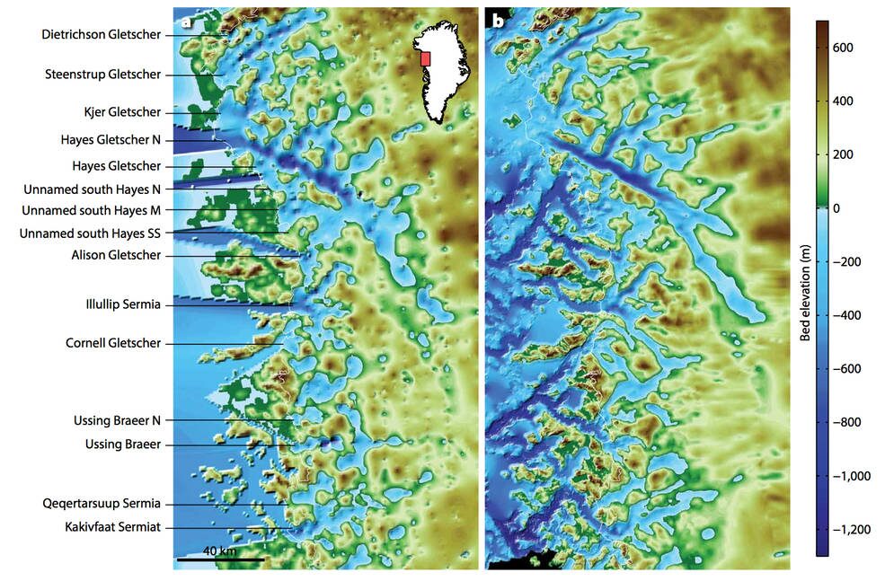
The above figure shows Bed elevation and bathymetry of Northwest Greenland from Bamber et al back in 2013 and from mass conservation combined with OMG data how some areas are warmer and it is causing salty ocean water to reach inside inland that was not expected and which is causing faster melting of glacier ice sheet. Due to NASA’s OMG mission, we are able to identify glaciers as land-terminating, however, they are marine terminating.
Image Source: https://i2.wp.com/climate.org/wp-content/uploads/2017/04/joost-2.png
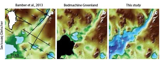
The above image depicts Bed elevation under Savissuaq Gletscher Bamber et al in 2013, Morlighem in 2014 by using mass conservation. It also includes bathymetry data. Areas below sea level are blue. Bamber et al data identify Savissuaq Gletscher as land-terminating, on the other hand, Morlighem et al. data clearly show that it is indeed marine terminating. These conclusions can only be made by the first set of observations made based on OMG. To evaluate and come to any conclusion more research needs to be performed and we can see better results by the end of mission completion (2020).
Lastly, we want to say, NASA is a federal agency which is dependent on the budget passed by US congress. It has been known that Trump administration is working to reduce spending on climate change and all climate-related research. Trump’s budget proposal demands cuts to NASA and NOAA Earth Science programs. However, we want to say that research must go on because it’s only through research and development we can come to any conclusion. We need to data from NASA as well as NOAA in order to analyse how warming oceans will affect Greenland ice sheet and sea level rise. There are numerous questions that need to be answered concerning our planet Earth.

